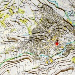
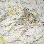
This 3D map created by Kath and Andy Wimble shows just how Southwell sits in a valley with the dumbles that flow into the main water-course – the Potwell Dyke. It also shows the secondary water-courses which flow from Halam Hill and Norwood Park. Photographed by Chris Knapton, Richfield Industrial In an interview with the… Read more »
Halam Hill
3D map helps raise flooding awareness
A 3D model of Southwell has been created in a bid to understand what caused the recent flooding. The map uses contour lines to demonstrate the gradient of hills to show how run-off from neighbouring fields flowed into the Potwell Dyke, also known as the Dumbles, and down into the town. More than 140 homes… Read more »