Southwell Flood Forum
  • Supporting a Resilient Southwell
  • Fundraising
  • Flood Report Form
  • Calendar
  • Blog/Press
  • Gallery
  • Resources
  • Contact

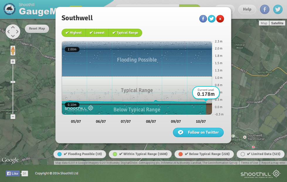
Shoothill GaugeMap

Posted July 19, 2014 & filed under Alerts, Blog, Community Resilience, Flood Mitigation, Potwell Dyke Flood Group, Watercourse Clearing.

The new Shoothill GaugeMap shows river level data for the River Greet in Southwell.

Shoothill GaugeMap

Categories

  • Alerts
  • Blog
  • Community Resilience
  • DEFRA Pathfinder Projects
  • Emergency Planning
  • Events
  • Flood Mitigation
  • Flooding News
  • FRAMES
  • Fundraising
  • Halam Hill Flood Group
  • In The Press
  • Insurance
  • insurance – Flood Re
  • Lower Trent & Erewash Catchment
  • Media Interviews
  • National Flood Forum Bulletins
  • National Flood Resilience Review
  • Natural Flood Management
  • Nottingham Trent University
  • Planning
  • Potwell Dyke Flood Group
  • SuDS
  • The University of Nottingham Community Participation Workshops
  • Trent Rivers Trust
  • Videos
  • Watercourse Clearing

Forthcoming Events

  • No Events

Tweets

  • Southwell survives a wet February! Events and information. - https://t.co/yNbUbiPVg4 01:21:25 PM March 08, 2020 ReplyRetweetFavorite
  • Dates for your diary and opportunity to help with research - https://t.co/T1ZFDUm62f 10:22:58 AM February 01, 2020 ReplyRetweetFavorite
@southwellflood

  • Home
  • About Southwell Flood Forum
  • Press Kit

© 2021 Southwell Flood Forum